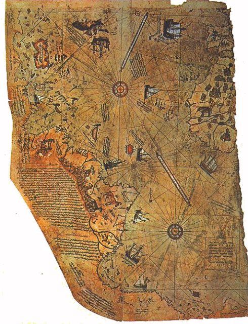
In 1929, researchers discovered an old map tucked away in the archives of Topkapı Palace in Istanbul. It was drawn on gazelle skin, signed by Ottoman admiral Ahmed Muhiddin Piri, and dated to the year 1513. The map remains part of the museum’s collection and has occasionally been placed on public display, as reported by Daily Sabah.
The map displayed the coast of Africa and South America with surprising accuracy. It also included a southern landmass that resembled the northern outline of Antarctica. What caught everyone’s attention was not just its presence, but the fact that it appeared free of ice.
What Makes This Map So Unusual?
The most puzzling element of the map lies in its depiction of a landmass far to the south. Some believe it matches the subglacial contours of Queen Maud Land in Antarctica, which were only confirmed by seismic surveys in the 20th century. If this reading is correct, then the Piri Reis map contains information that would have required either satellite-level knowledge or access to ancient sources we no longer possess.
Others offer a more conservative interpretation. They suggest that the southern land was simply an extension of South America, drawn in error, or that it reflected common geographic speculation at the time. Renaissance maps often filled in unknown regions with conjecture or inherited assumptions from older traditions.
Even if the Antarctica theory is set aside, the map’s accuracy along the African and South American coasts is still impressive. This level of detail seems advanced for 1513, especially considering how incomplete European exploration of those regions was at the time.
Where Did Piri Reis Get His Sources?
Piri Reis left behind notes describing how he made the map. He claimed it was based on roughly 20 earlier charts, some of which he attributed to Portuguese explorers and others to sources dating back to the time of Alexander the Great. He also mentioned that some of his data came from “ancient times” but did not specify how far back.
If his account is taken seriously, it suggests he was working with maps that preserved knowledge from earlier, possibly lost civilizations. Some researchers have speculated that these could have been Phoenician, Egyptian, or Greco-Roman in origin. Others go further, proposing that the data may have come from a civilization predating recorded history.
What Can We Really Say About the Map?
The Piri Reis map is a verified historical document. Its age is not in question, and its basic geography is remarkably detailed. What remains unclear is how Piri obtained such precise information about certain regions.
Mainstream scholars argue that he simply drew from the best sources available at the time, using fragments from early explorers and geographers. But even that raises questions about how those earlier sources acquired their data in the first place.
The map has become a touchstone for anyone interested in lost knowledge. Whether one views it as a clever compilation or a relic of something much older depends on how much weight is given to what the map shows compared to what the official record says should have been known in 1513.
Final Thoughts
The Piri Reis map does not shout its mystery. It suggests, it hints, and it lingers. Its details do not demand attention, but they raise quiet questions that continue to unsettle the boundaries of what we thought we knew. Whether it reflects ancient memory or remarkable insight, it reminds us that the past is often more layered than it appears.
And now it’s your turn to explore the unknown.
Share your thoughts in the comments, and follow The Time Traveller’s Diary for more strange discoveries, historical anomalies, and forgotten clues from the past.
- The Mycenaean legacy: how Greece remembered itself
- Stoicism in Uncertain Times: Ancient Wisdom for Modern Anxiety
- The Map That Shouldn’t Exist: The Mystery of the Piri Reis Chart
- The Sky Stone of Sierra Leone: A Geological Mystery or a Forgotten Artifact?
Discover more from The Time Traveller's Diary
Subscribe to get the latest posts sent to your email.
